
QUEMIC AIRBORNE
Advanced Drone Technology & Aerial Intelligence
Enterprise aerial technology combining high-resolution imaging, thermal detection and intelligent flight systems for surveillance, inspection and complex operations across South Africa.
Advanced Drone Technology. Clearer Operational Insight.
Enterprise aerial technology for surveillance, inspection and complex operations across South Africa.
Quemic Airborne combines enterprise drone technology, advanced imaging systems and professionally managed flight operations to deliver accurate aerial intelligence across South Africa.
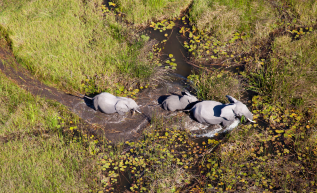
Our aerial platforms integrate high-resolution visual imaging, thermal detection, powerful zoom and intelligent flight technology to support security surveillance, infrastructure inspections, conservation monitoring and operational decision-making.
From live aerial observation to detailed post-flight analysis, every operation is designed to provide clients with clearer visibility, faster insights and reliable information from above.
Technology Behind Every Operation
Advanced imaging, thermal detection and intelligent flight technology provide Quemic’s teams with clearer aerial visibility and decision-ready information.
Advanced
Visual Imaging
Intelligent
Flight Systems
Advanced positioning, flight planning and obstacle sensing support accurate, controlled aerial operations.
Thermal
Detection
Thermal imaging reveals heat signatures to support surveillance, inspections and night-time operations.
Aerial Data
& Reporting
Low-Light
& Night Operations
Low-light and near-infrared technology provides clearer aerial visibility during night-time and low-visibility operations.
Digital Mapping
& Data Capture
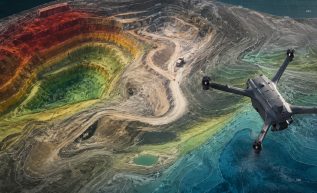
Aerial imagery is captured into detailed maps, terrain models and visual datasets that support site assessment, planning and operational decision-making.
Enterprise Drone Platforms
Quemic Airborne operates enterprise-grade drone platforms developed for reliable performance across security, inspection, conservation and infrastructure environments. Advanced positioning, multi-sensor imaging, obstacle-sensing technology and reliable communication systems support stable, controlled aerial operations across complex and demanding locations
Capability points:
Stable, precision flight
Advanced positioning technology
Intelligent obstacle sensing
Multi-sensor imaging capability
Rapid operational deployment
Day and night operations

HOW OUR DRONE OPERATIONS WORK
Operational
Assessment
Based on the mission requirements, the appropriate drone systems and sensor payloads are selected and configured to ensure optimal performance and accurate data capture.
Mission
Planning
Certified drone pilots plan and execute aerial missions using advanced flight planning software. All operations are conducted in accordance with aviation regulations and strict operational safety protocols.
Data Capture &
Processing
During flight operations, high-resolution imagery and sensor data are captured and processed using specialised software to generate aerial datasets, maps and visual models.
Reporting &
Data Delivery
Aerial data is delivered through reports, visual outputs or digital platforms, providing clients with accurate information to support operational planning and decision-making.
Need a tailored aerial intelligence solution?
Speak to our team about environment, compliance
requirements, and operational objective
SACAA-Licensed
Commercial drone operations conducted within South African aviation requirements.
Enterprise Technology
Professional aircraft, autonomous docking systems, thermal cameras and specialist sensors.
Operational Experience
Field-ready teams equipped for complex, remote and demanding environments.